Flood risk remains high as more orange and yellow rain warnings issued

Ellen O'Donoghue and Vivienne Clarke
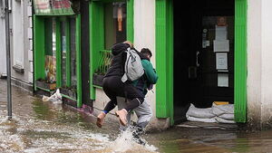
A status orange rain warning has been issued for two counties, and a status yellow rain warning has been issued for nine counties.
It comes after Met Éireann warned of a risk of flooding and high spring tides in coastal areas after January rainfall was higher than usual.
Wicklow and Waterford will be under a status orange rain warning from 3am on Thursday until 3am on Friday.
Meanwhile, Carlow, Dublin, Kildare, Kilkenny, Laois, Louth, Wexford, Monaghan and Tipperary will all be under a status yellow rain warning, also from 3am on Thursday until 3am on Friday.
Met Éireann has warned that spells of very heavy rain falling on already saturated ground combined with high river levels and high tides could lead to localised flooding, river flooding with potential impacts along the entire course of the river, and difficult travel conditions.
The warnings come as local authorities, especially in the south east, warned of possible flooding for the remainder of the week.
Met Éireann has warned of a risk of flooding and high spring tides in coastal areas, after January rainfall was higher than usual.
Government Ministers met with the National Emergency Coordination Group to review warning systems for weather events and to discuss recent flooding along the Eastern and Southern coasts on Tuesday.
The NECG is advising people to allow for disruption when travelling and to plan for extra travel time.
Rebecca Cantwell, Forecaster with Met Éireann, told Newstalk that there has been a lot more rain than normal at this time of the year.
"Right through the month of January we’ve had, particularly in the south and east, we’ve seen three to five times the average rainfall that we’d expect for the time of year in these areas, so it’s been very wet, and it is going to continue to be wet even if it’s not particularly very heavy rainfall that we’re expecting, it is falling on already saturated ground rivers are at or about bankfull conditions," she said.
Met Éireann’s Andrew Doran-Sherlock also warned that just because the rain has stopped, flooding remains a risk.
“It's important to note that even when it's not raining, there are some delayed responses in some rivers and catchment areas, so the risk of flooding doesn't necessarily stop just because the rain has stopped; there can be delayed responses,” he told RTÉ radio’s Morning Ireland.
Doran-Sherlock urged people to pay attention to weather conditions and river gauge data.
"You can check what water levels are, but really your local authorities will have the best guidance because they'll have a good idea of the response times of the rivers in their areas and things like that," he said.
“We've got high river levels somewhere at bank full or above and at this stage any amount of any further rain or showers could lead to larger impacts. So especially as we head into tomorrow with further heavy rain and with strengthening easterly winds so for onshore coastal areas around high tides there's the risk of coastal flooding, but we're dealing with further heavy rain coming.”
Meanwhile, Keith Leonard from the National Directorate for Fire and Emergency Management has said that “absolutely every engineering solution and every kind of interim measure that can be taken” is being taken to try and deal with the record-breaking levels of water in river catchments around the country.
“We've seen a moderate amount of rainfall and some flooding in areas, but nothing significant in the last 24 hours, but what we're looking at I think today and particularly into tomorrow is difficult conditions across that eastern region," he said.
"I think the Nore, the Barrow, the Slaney and the Liffey catchments are going to see very high levels right across this evening and into tomorrow,” he told RTÉ radio’s Morning Ireland.
“We're in a very unusual situation now, where even rainfall below the warning thresholds can have an impact across the rivers and sometimes the rainfall, the impact lags behind the rainfall so you could have impacts right up until Friday.”
Mr Leonard said that staff in councils that are less affected are moving equipment to where the key pinch points are.
There is a coordinated response, particularly in the Dublin area and in that south eastern area, where local authorities are meeting with each other on a regular basis to coordinate their operations.


